Fail:Relief Map of Poland.svg

Saiz pratonton PNG bagi fail SVG ini: 617 × 600 piksel . resolusi suai: 247 × 240 piksel | 494 × 480 piksel | 790 × 768 piksel | 1,053 × 1,024 piksel | 2,107 × 2,048 piksel | 861 × 837 piksel.
Fail sandad (Pail SVG, tipong tuou 861 × 837 piksol, ginayo pail: 4 MB)
Koinibaan
| pongowowoyoon |
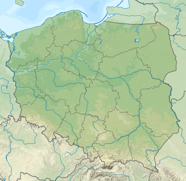
Deutsch: Positionskarte von Polen
Quadratische Plattkarte, N-S-Streckung 160 %. Geographische Begrenzung der Karte:
English: Location map of Poland
Equirectangular projection, N/S stretching 160 %. Geographic limits of the map:
|
| Tadau Wulan | |
| kowonuan |
Karaja sondii This vector image includes elements that have been taken or adapted from this file: This vector image includes elements that have been taken or adapted from this file: |
| Sanganu |
TUBS |
| Versi lain |
|
| SVG genesis | This map was created with Adobe Illustrator by TUBS. |


Pongolisinan
Dengan ini, saya selaku pemegang hak cipta karya ini, menerbitkannya di bawah lesen yang berikut:
Fail nopo diti nga id siriba lesen Creative Commons Attribution-Share Alike
3.0 Unported.
- Obibas ko:
- montok popoilang – montok mamadalin, popotikid om popoundaliu asil karaja
- montok popilongot – montok poposudong do kalaja
- Id siriba do syarat dilo:
- Pongokunan – Nuru ko do mongounsikou, manahak popioput kumaa lisin, om popokito sokiro haro kosimbanon di winonsoi. Milo ko do popowonsoi nunu nopo laang ii kosudong, nga' okon ko' id suang do nunu-nunu nopo laang di poposogu do minanahak lesen do monokodung diya toi ko' pomogunoon nu.
- poilango kopiagal – Sokiro nopo monimban, popirolot toi ko' momoruhang ko do kakamot, minog do pasarabakon o sakadai nu id siriba lesen same or compatible license miagal di intodon.

|
I'd greatly appreciate, that you attribute this media file to Wikimedia Commons, if used outside Wikipedia or Commons. For use in publications such as books, newspapers, blogs, websites, please insert here the following line:
|
Sajara fail
Todoso id kalindo / maso do mongintong di upa dilo fail ontok di timpu nokomoi.
| Tadauwulan/Maso | Sinondulu | Ginayo | Moomomoguno | Komi | |
|---|---|---|---|---|---|
| timpu diti | 07:20, 1 Momuhau 2021 | | 861 × 837 (4 MB) | Puck04 | fixed SVG code (was "W3C-invalid") + cleanup using text editor; contains raster graphics however |
| 04:54, 4 Mansak 2021 |  | 861 × 837 (4.18 MB) | SANtosito | Vectorized topo | |
| 05:52, 1 Momuhau 2011 |  | 861 × 837 (4.87 MB) | TUBS | == {{int:filedesc}} == {{Information |Description={{en|Relief map of Poland}} Equirectangular projection, N/S stretching 160 %. Geographic limits of the map: * N: 55.2° N * S: 48.7° N * W: 13.8° E * E: 24.5° E |Source={{own}}{{Adobe Il |
Pomogunaan do fail
Iti kiharo 3 bobolikon poingoput id pail diti:
Pomogunaan fail sompomogunan
Fail diti ginuna do wiki suai:
- Kopomogunaan id ab.wikipedia.org
- Kopomogunaan id als.wikipedia.org
- Kopomogunaan id ar.wikipedia.org
- Kopomogunaan id av.wikipedia.org
- Kopomogunaan id azb.wikipedia.org
- Kopomogunaan id az.wikipedia.org
- Şablon:Yer xəritəsi Polşa
- Əyri meşə
- Slovinski Milli Parkı
- Dzivna boğazı
- Yamno gölü
- Baltik dili
- Şablon:Dil (coğrafiya)
- Şablon:Dil (coğrafiya)/doc
- Xel dili
- Blendovka səhrası
- Morskie Oko gölü
- Belka-Snejna mağarası
- Karsibur adası
- Ambarlar adası
- Qrabovski adası
- Haliç dağı
- Jives gölü
- Rozeve burnu
- Lısa-Gora dağı
- Avqustovskaya puşa
- Tuxolskie borı
- Rastoçe
- Rominten meşəsi
- Solina gölü
- Qartal Yuvası təbiət parkı
- Çarne gölü
- Pienini dağları
- Tatra Milli Parkı
- Kopomogunaan id ban.wikipedia.org
- Taman Nasional Tatra, Polandia
- Taman Nasional Bieszczady
- Lis taman nasional ring Polandia
- Taman Nasional Wielkopolska
- Taman Nasional Pieniny (Polandia)
- Taman Nasional Gorce
- Taman Nasional Babia Góra
- Taman Nasional Białowieża
- Taman Nasional Biebrza
- Taman Nasional Kampinos
- Taman Nasional Narew
- Taman Nasional Wigry
- Taman Nasional Magura
- Taman Nasional Roztocze
Intangai lobi momomoguno sompomogunan do pail diti